
Page 2 - 2013 Paganninawan 3rd Quarter
P. 2
2
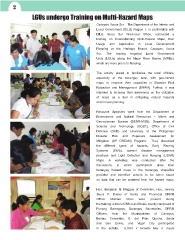
LGUs undergo Training on Multi-Hazard Maps
Caoayan, Ilocos Sur – The Department of the Interior and
Local Government (DILG) Region 1, in partnership with
DILG Ilocos Sur Provincial Office, conducted a
training on Understanding Multi-Hazard Maps, their
Usage and Application in Local Development
Planning at the Heritage Resort, Caoayan, Ilocos
Sur. The training targeted Local Government
Units (LGUs) along the Major River Basins (MRBs),
which are more prone to flooding.
The activity aimed to familiarize the local officials,
especially at the barangay level, with geo-hazard
maps to improve their capacities in Disaster Risk
Reduction and Management (DRRM). Further, it was
intended to increase their awareness on the utilization
of maps as a tool in mitigating natural hazards
and in local planning.
Resource Speakers were from the Department of
Environment and Natural Resources – Mines and
Geo-sciences Bureau (DENR-MGB), Department of
Science and Technology (DOST), Office of Civil
Defense (OCD) and University of the Philippines’
Disaster Risk and Exposure Assessment for
Mitigation (UP DREAM) Program. They discussed
the different types of hazards, Early Warning
Systems (EWS), current disaster management
practices and Light Detection and Ranging (LiDAR)
Maps. A workshop was conducted after the
discussions in which participants drew their
barangay hazard maps in the barangay shapefiles
provided and identified actions to be taken based
on data that can be acquired from the hazard maps.
Hon. Benjamin N. Maggay of Cervantes, Hon. Jeremy
Jesus P. Bueno of Santa and Provincial DRRM
Officer Michael Chan were present during
the training. A total of 288 local officials, mostly composed of
Punong Barangays, Barangay Secretaries, DRRM
Officers, from the Municipalities of Caoayan,
Bantay, Cervantes, G. del Pilar, Quirino, Santa
and San Emilio, and Vigan City participated
in the activity. (LGOO II Nicolette May O. Amon)